Sometimes you wonder about time machines or how to write an interesting history lesson about something that occurred 300 years ago.
There are many noteworthy rivers in Northern Ontario. Two of them have important natural and cultural attributes, many have changed over time; some have stayed the same.
The Ottawa and Abitibi Rivers are not joined because of the height of land between their watersheds, they are close enough together to join Montreal on the St. Lawrence River with James Bay (Moosonee) by water.
A few years ago Pierre de Troyes utilized this link in 1686, an amazing, and 82-day trek through northeastern Ontario with help from the Algonquins.
He travelled more than 800 miles (1,300 km). The route, in general, was up the Ottawa River to Lake Temiskaming, through unexplored territory, then portaging the height of land and down the Abitibi and Moose Rivers.
Who’s he?
“A captain in the French army de Troyes arrived at Quebec in August 1685 with reinforcements for the colony," says the Canadian Museum of History. "On March 20, 1686, with a party of twenty Troupes de la Marine (marines) and sixty Canadien militiamen (selected for their canoeing skills) out of Montreal, he led a mission to chase the English from James Bay (then known as the bottom of Hudson Bay).
"He is ordered by the Governor to leave Québec to occupy the posts on the shores of the Northern Bay. The troop consists of 30 soldiers and 70 Canadians chosen for their ability to travel by canoe. A drummer, an interpreter, one or more carpenters and a blacksmith are part of the group which is equipped with swords, tools, pickaxes, spades and shovels."
He made use of canoes for transportation in voyageur style, following the Ottawa River north, portaging by way of Lake Timiskaming and Lake Abitibi (then on to the Abitibi River).
The northern assault caught the British by surprise and captured Moose Fort (Fort Monsoni-Moosonee) with ease on June 20. On July 3 de Troyes took Rupert House (Charles Fort) along with the small sailing ship, the HBC Craven, which he used to travel to Fort Albany (Fort Quichichouane, on the Sainte-Anne River or Albany) which fell on July 26.
Fast forward, by 1696 the British recaptured Fort Moose. In 1713, the Fort Moose area was formally given to the British under the Treaty of Utrecht.
So I got to thinking, what did de Troyes see along the way then, that is the same today, and what has changed drastically?
Help
When you try and relive the past there are blanks of information to fill.
Why?
This expedition occurred because of the French-English fur trading. It was a by-product of economic conflict and part of that was the problem of how to travel through Algonquin lands.
Peter Di Gangi, is an expert on Indigenous historical, legal and cultural research, especially in northeastern Ontario and the Ottawa River watershed. He has completed extensive work for the Algonquin Nation Secretariat and his good overview is included within the document, Treaties and the Treaty Relationship, – Algonquin Territory.
“The traditional territory of the Algonquin people has always included the Ottawa Valley and adjacent lands, straddling the border between what is now Quebec and Ontario," Di Gangi said. "Unlike most of Ontario and the Prairies, Algonquin territory has never been dealt with by a land-sharing Treaty. Algonquin title continues to exist.
“With the arrival of the Europeans, the ancestors of today’s Algonquins were already well-established in the Ottawa Valley. Initially, the people who now identify as Algonquins were known by a variety of names.
"The Jesuit priest Pierre François Xavier de Charlevoix, in his 1744 Journal of a Voyageto North America, mentions the Algonquins, Nipissings, Timiskamings, Têtes-de-Boules, and Gens des Terres. By the end of the nineteenth century,
"'Algonquin' had become regularized to refer to those peoples occupying the Ottawa River watershed whose neighbours were the Mohawks (to the east), the Atikamekw and Cree (to the northeast and the north), and the Anishinaabe (to the west and the south).” (Treaties and the Treaty Relationship).
Di Gangi said De Troyes received specific “instructions for his expedition.”
“They had to walk a fine line between politics and business. France and Britain were not at war. This was about the economic interests of businessmen in New France.
“Order from Governor Denonville naming Chevalier de Troyes as Commander of an expedition to Hudson Bay – treason by Radisson who seized his nephew Chouart and the goods of the Compagnie du Nord at Nelson River; de Troyes has orders to occupy the most advantageous posts on said bay and to seize renegades like Radisson.”
Pierre-Esprit Radisson is mentioned because as a French fur trader, he is often linked to his brother-in-law Médard des Groseilliers. Radisson and Groseilliers, (a.k.a. Radishes & Gooseberry), changed sides and entered the English service which led to the formation of the Hudson's Bay Company on May 2, 1670.
His life in New France is notable for its repeated transitions between serving Britain and France. De Troyes headed north to protect the French investments taken over by the HBC.
“The muster will take place at Ville Marie on the Island of Montreal between the 8th and 10th March so that the expedition can get underway on the 14th of the same month in order to travel on the ice as long as it lasts and follow the route that leads to the Themiskamingues, and from there by way of the Abitibis as far as the northern Bay.
“During the expedition, Monsieur de Troyes will be careful to post sentinels around his camp and assign them in such a way that they cannot be taken by surprise. Monsieur de Troyes will also ensure that he has a small guard to be called on in case of need as well as to maintain discipline."
All of the above instructions are prepared by the Algonquin Nation Secretariat, 14 September 2022; translations by James Morrison; Feb. 12, 1686: Instructions (in French) from Marquis de Denonville, Governor of New France to Chevalier de Troyes. LAC MG1 C11A Vol 8, fos 262-267v, Reel F.
The Route
De Troyes started in Montreal, two great rivers were utilized to reach James Bay.
The Ottawa River forming for most of its course the Quebec–Ontario provincial border before it joins the St. Lawrence west of Montreal runs a total course of 790 miles (1,270 km). Its watershed tributaries drain an area of more than 55,000 square miles (142,000 square km). It is the 13th longest river in Canada.
The Abitibi River flows northwest from Lake Abitibi, just east of Iroquois Falls to join the Moose River which empties into James Bay. This river is 540 kilometres (340 mi) long and descends 265 metres (869 ft). It is the fourth longest river in Ontario.
Abitibi is an Algonquin word meaning halfway water, derived from abitah, which may be translated as "middle" or "halfway", and nipi, "water.” Originally used by the French to designate a band of Algonquin indigenous peoples who lived near the lake, the name was descriptive of their location halfway between the trading posts on the Hudson Bay and those on the Ottawa River.
From this story’s map, you can see all of the road bridges, railway trestles, dams and ferries that cross the Ottawa River from Montreal to James Bay. From Montreal to Mattawa the map is busy, things have changed.
“His journals of the trip to James Bay are the first detailed European account of the country occupied by the “Themiskamingues” and “Abitibis”," said Di Gangi. "They left Montreal March 1686. On May 1, 1686, near Calumet Island, they met some “Themiskamingues” who were on their way to Montreal to trade.
“Third week of May they reached Lake Timiskaming.
"They made various stops including at the trading post at the mouth of Matabitchuan River and on Chiefs Island.
"On 26 May they headed north by way of the Blanche and Windigo Rivers. They passed through lake Opasatika and over the height of land on the 31st. June 1 they were at Lac Dasserat and they met Abitibi people.
“On the way back five days from Abitibi to Timiskaming. They were at the Timiskaming post on Sept. 7. From there they retained an unnamed Chief of the Themiskamingues as a guide to take them back to Montreal.
"Based on other information we at the Algonquin Nation Secretariat believe that this was likely the Chief known as Routin / Wattaine, who is mentioned a lot in English and French records of this period, and who trade at James Bay and at Montreal.”
Then and Now
There was/is much to see along the way.
From his journals he did stop at the ‘Meeting of the Waters,’ the confluence of the Mattawa and Ottawa Rivers. The community’s three crosses were not yet there perched on the high, north side of the Ottawa River, but he did erect a roughly hewn cross on Explorer’s Point commemorating the expedition.
The Hardy Boys novel series was not yet written. There is no doubt he would have seen the dynamic Devil’s Rock near Haileybury-North Cobalt.
For some reason, as Di Gangi states, de Troyes did not take the more direct route to Lake Abitibi. It is known he was guided by an Algonquin Temiskaming Chief.
Just past the bear-like erratic at Dawson Point, (see photo) northeast of New Liskeard (Temiskaming Shores) they turned and entered the Blanche River and then the Larder River.
Taking the Blanche River de Troyes would have paddled past the Hilliardton Marsh Research & Education Centre.
Further north on Lake Abitibi he would have crossed the historic portage on Long Point and paddled through the park named after him. Some of the artifacts within the Jordan collection exhibited at the Iroquois Falls Public Library would have been scattered along the lake’s exposed beaches. These will be repatriated.
Near the height of land, he would have seen the bulbous Mount Cheminis in the distance. He would not have had the time to climb up for the expansive view.
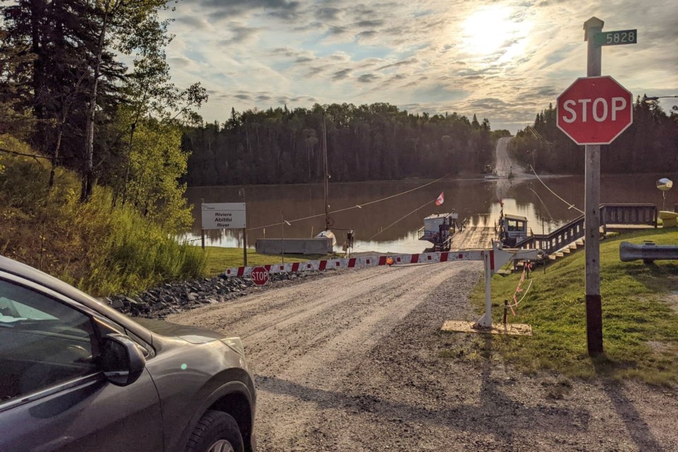
Now on the Abitibi River, he would not have seen the most northern ferry crossing northwest of Cochrane, including the winter ice bridge or at the Abitibi Canyon Generating Station the voluminous water cascading down the sluiceway. New Post Falls was perhaps a stop along the way as it would have a natural camping area for they would have seen one of the most spectacular falls in the north.
Epilogue
A few weeks after his return, Governor Denonville of New France expressed his satisfaction to the Marquis de Seignelay, Minister for the Colonies.
“The sieur de Troyes is the smartest and the most capable of all our captains. He has the kind of spirit needed to command others.
"There can be no better example than the behaviour he demonstrated during our Northern undertaking where he needed to be very clever to get the Canadians to deliver the kind of service and dedication they demonstrated,” (Canadian Museum of History).
It was shortly thereafter de Troyes was sent to Fort Denonville (now Fort Niagara) in his own honour, de Troyes was left in charge. He died on May 8, 1688, along with most of the troops in his garrison, due to scurvy, he was in his early forties.
There is little to mark what de Troyes accomplished. Through the Ontario Heritage Trust and its Provincial Plaque Program, there is a De Troyes Expedition 1686 plaque on the east side of De Troyes Avenue between Church Street and Teefy Street. I tried to find out by whom and when this plaque project was initiated but to no avail, maybe a reader will know?
You can see the de Troyes expedition here.
A great deal of time was spent on the map so click on the way more than 100 pins in the legend and get to know the two rivers.
It is an interesting scroll/pan along the Ottawa River. From the Trans-Canada Highway vehicle bridge at Montreal (Lake of Two Mountains) to the Mattawa, Ottawa Valley Railway trestle (three crosses) there are at least five train trestles (some abandoned), twelve vehicle bridges, six ferries, and seven dams that cross the river, along with five lighthouses. Count them and report back.
At the upper end of Lake Temiskaming, you can trace an upper Ottawa River tributary to the height of land; you can also see the route taken by Pierre de Troyes via the Blanche and Larder Rivers to the height of land.
The height of land straddles Highway 65 in Ontario (Virginiatown) and then it becomes Highway 117 in Quebec. Just east of the turnoff to Mont Kanasuta ski resort and the road to Lac Kanasuta you can stop your car.
On the south side of Highway 17, the water in the ditch/wetland flows to the St. Lawrence River. On the other side, there is a small creek which flows northward.
You can see where the contour lines cross the highway and there is no sign denoting this unique location as the height-of-the-land line oscillates across Northern Ontario.
Escorted by indigenous guides there would have been a portage from a wetland to a creek (near points #143, #144 and #118 on the map) to access the two watersheds and the tributaries of the Ottawa-south/Abitibi-north watersheds.
From Mattawa at the confluence of two rivers, north to Lake Temiskaming, to James Bay (Moosonee), spanning the two watersheds and two provinces there is at least one vehicle ferry, six power dams, three railway trestles and eleven smaller road bridges.
There is a great deal of natural and cultural heritage on the back roads, take the time to appreciate what was then, and now.


