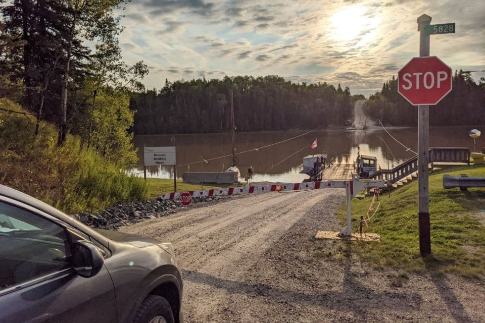
With little warning, there’s a very sharp inverted, right-angled turn on Highway #579 the pavement also unexpectedly ends, you’re braking alright.
The gravel roadbed starts to immediately slope down to the river, past the flapping Canadian and Ontario flags and warning signs where there is a different-looking sort of barge. The view ahead is open water, light brown but solid in colour, it’s very turbid; you can see the other side but there is no bridge.
It takes just under two minutes to cross the 230 metres (755’) of open water, at about 10 kph (6 mph), and it is the most northern cable ferry in Ontario.
Yes, there are ferry crossings in Northern Ontario. This is the year-round car/truck ferry crossing/ice bridge on the Abitibi River 32 km northwest of Cochrane. And it is an “ice bridge” not a winter road.
Highway 579 was extended north of the Abitibi River in the late 1950s. After fording the Abitibi it continues for approximately five kilometres on the east side of the river, terminating at the Ontario Northland Railway (ONR) track. There are four permanent residents on the other side of the river within Gardiner a 'dispersed rural community' (a recognized place name descriptor) within the unincorporated Blount Township.
The ferry is also used by ONR personnel and logging operators. The vast majority of users, about 6000 trips per year, cross the river to access hunting and fishing camps and the busiest time is the May long weekend.
The Abitibi River flows northwest from Lake Abitibi to join the Moose River which empties into James Bay.
This river is 540 kilometres (340 mi) long, and descends 265 metres (869 ft); It is the fourth longest river in Ontario there are not many crossings. There are only two roadway bridge crossings. One is located at the toll redevelopment project and it is a single-lane, open deck steel trestle at Iroquois Falls. The other is on Highway 652 East of Cochrane.
There are also three railway trestles and six hydro dams on the route headed northwards (a lesser tributary road bridge crosses Hwy. 11, west of Cochrane).
Justin Bryant is the Communications Coordinator, MTO, Northeast Operations, Regional Services and Relationships Office.
“Since 2010, the Gardiner Ferry has been operated by Integrated Maintenance and Operations Services Inc. (IMOS), (Miller Group), as the area maintenance contractor on behalf of the province," Bryant said.
During the winter season, IMOS begins the process of constructing the ice road (conditions permitting).
The ice road is constructed over a seven-to-10-day period by flooding the river ice surface with water and installing steel reinforcement cables at each end of the crossing. Once it’s been determined that the total thickness of the ice can safely accommodate vehicles, the ice-bridge road is opened and the ferry service is temporarily halted for the winter season.
“Although the Gardiner Ferry is in a northern part of Ontario, polar bears are not seen at this crossing however the operator may get asked about polar bears on occasion from an interested tourist.”
This may be because of the Cochrane Polar Bear Habitat exhibit.
“Summer staff includes three full-time, two part-time. Winter is one full-time," said Bruce Kitching of the Miller Group. "Crossings are variable but usually at least 6,000.
"[We have] No stats on the ice road.
"The road is maintained for approximately 3 km on the east side then turns into a forest access road.
"The ferry can accommodate up to 35 tonnes (a loaded logging truck fits) and the ice road weight limits vary depending on ice thickness with a target thickness of 90cm or greater for full traffic.”
Patrick Ray is the new sub-contractor/operator and has been on the job for about three months.
“There is no propeller on this boat,” he said.
There is much to learn about the 'half-inch' cable (two winches, two cables) that runs back and forth across the river (there is a spare, in case it breaks and it has).
The ferry (barge/boat ) is the Cassiopeia IV run by a 60 horsepower diesel and there are two gears on it - forward and reverse.
Hoses, gauges and levers are obvious on the Cassiopeia and when it suddenly starts the rumble it is even more obvious that the motor is meant for work. The rumbling sound is the engine's unique mixture of pressure and ignition causing its signature noise.
Back in 1957, there was only a hand winch and crank. The black and white photo on the check-in office wall shows the operator with massive arms, it was a smaller boat back then.
The Cassiopeia IV is 15.2 m long, (26.2 m with the ramps) and 7.3 m wide. It has a carrying capacity of 35 tonnes and there are no snacks like on Porter Airways. It takes between 1:55 to 1:58 seconds to cross depending on the current and who is piloting.
You have to wait for the safety arm to rise before you can go and your wheel is locked down on the deck.
While on the return trip from the east side of the river I meet full-time residents Karen and Louis Dingley headed into town. They purchased a property they described as 'a good buy' on nearby Gardiner Lake four years back.
In the summer they use the ferry three to four times per week and in the winter using the ice bridge once per week.
For the most part, they are satisfied with the service but there was once a six-week period where the ferry was not running due to a repair/parts shortage which left them stranded.
Apparently, during the other three seasons, there is a circuitous unmaintained forest road that allows for an alternative, elongated access (Florence Lake). It ends up on Highway 652 far to the east of Cochrane on the way to the Detour Lake gold mine.
Ice Bridge
What about the winter? Maurice Robin knows how to make ice. He just retired from being the Abitibi River sub-contractor after fifteen years of making the ice bridge and operating the ferry. He was born and raised in Cochrane.
There is only one ice bridge on our provincial highway network.
What then is an ice bridge? Looking ahead, be a winter tourist this 2023 and take the opportunity to do the double crossing of the ice bridge.
It is a bridge, developed by watering above the existing ice to create a new, deeper, stronger surface. There are few such natural infrastructures, engineered like this one, in the world. The reinforcing cables suspended within the ice are different. It is sort of like a wire mesh. That’s so neat.
There is a difference between seasonal winter roads and the ice bridge on Highway 579 at Gardiner.
The ferry and ice bridge are both funded and maintained by the Ministry of Transportation (MTO).
But the winter roads in Northern Ontario are not the responsibility of the (MTO). They are administered by the Ministry of Northern Development and Mines. Winter roads are built over land, frozen rivers and lakes by remote communities and First Nation members. These roads connect remote and First Nation communities in the far north to a permanent highway or railway system.
From around mid-January until the spring thaw, winter roads make it easier to travel and bring in supplies. In 2020-21 the Ontario government invested $6 million to help 31 remote First Nation communities to build and maintain 3,170 kilometres of temporary snow and ice roads for the winter season.
Off of the winter roads, back to the ice bridge on the back roads.
Making a backyard rink is one thing, constructing an ice bridge suitable for cars and trucks to cross the Abitibi River, with a current, under northern weather conditions, (climate change variables) is another skill set worth appreciating. And listening to the expert, you feel like you could now change the float in the back of your toilet if you had to.
Maurice is passing his expertise on to Justin, the new operator, who he knew was the right person when one day, last year, they conversed in Canadian Tire.
"You have to have the aptitude and mechanical know-how something you learn after school,” Robin said.
There are probably not too many people anywhere who have the expertise to create ice bridges for vehicular traffic and in short order. He told me the seasonal ferry runs back and forth until the ice bridge is ready, there is no downtime.
In the late fall, Robin has to keep the ferry running every thirty minutes so the open water passageway through the growing ice, surprisingly very close (within 50 m) to where the ice bridge is made, is kept open while taking out giant 'ice cubes' that cause obstructions.
Robin describes the ice bridge as a floating raft tethered to each shore. On the ice bridge there is more than 100 cm (39 inches) of ice and over the banks, where there is a 3 kph river current of about 18 inches (45 cm). When I was there in 2016 for a Facebook post he buried his 42-inch oversized chain saw guide bar and there was no water to be seen.
He can have an ice bridge ready in about a week to ten days, depending on the weather and that is with applying 'not too much water' (that is where 'over flooding' causes mistakes) because people are in a hurry to grow ice.
Robin reminded me the best ice is the beautiful translucent blue ice and it is formed from above and below, with water percolating through. Snow insulates the ice, so he likes to keep the beginning of the bridge base clear with his amphibious Argo ATV, complemented with a blade attachment.
The ice bridge is very wide, not narrow, with a natural crown in the middle, Robin keeps 24 test holes along the route, 20’ (6 m) away from the banks
He starts out with an employee on shore while Robin is tethered with a rope and a life jacket. He needs five inches of ice (12 cm) before venturing out with the handheld ice auger.
He drags the water pump on a sleigh in the beginning. He needs to make sure he can get his water pump safely on the surface to drill holes along the route. He can then use a snowmobile running back and forth and by day three he can easily move the radiating spray from the pump.
Flooding starts from each side, working towards the middle, anchoring the raft of ice, (as the road gets wider there is more floatation and stability). A little snow allows for vibrating packing but large snowfalls are removed. He creates snow banks to dam the water in.
And then there are the countless other details making a bridge out of ice. There is no page 47 within the manual, there is no guide. The rest of the time he is on his own.
He needs a period of time with -25/30 degrees Celsius temperatures. Because of this, in 2015 the ice bridge was not ready until Jan. 19 and the ferry ran overtime.
When he has 14 inches of ice (35 cm) he unravels fourteen cables (0.5 inches thick), equally spaced, from a spool, all the way across the river; and then he quickly makes more ice on top of that again.
“It is like putting rebar (short for reinforcing bar) into concrete for additional support,” Robin said.
The cables are 18” (45 cm) apart so if a vehicle goes through the ice it is supported.
“Still people drive too fast as they are scared of the river crossing in winter," he added. "They think faster is better.”
These cables are recovered in the spring as they sink to the bottom of the river. At 18 inches of ice (45cm), light traffic is allowed and the thickness of the ice is posted – signs are up to 100 cm but there is always more ice than that in the middle of winter.
The road is then plowed by the MTO contractor and sand is not allowed on the road as it deteriorates the ice. Robin then regularly checks the ice depth for about three months. The ice continues to naturally thicken on its own.
He has never been through the ice. As springtime weather approaches Robin breaks the ice and nudges the ferry into the water, shunting it back and forth to make an open water track, at the same time keeping the ice bridge open (see the photo).
You meet interesting people on the back roads.
Robin is a pilot with 1,750 hours of flying time and once owned a tourist operation with outposts north of Cochrane. He has flown his Cessna 170 B, solo, more than 2,000 miles (3,200 km and that is a meandering route to gas sources and remote settlements) to Gjoa “Joe” Haven on King William Island, Nunavut.
He was inspired and motivated by Pierre Berton’s ‘The Arctic Grail: The Quest for the North West Passage and the North Pole, 1818-1909.’ Up and back in 11 days, with an average speed of 70 mph into a headwind.
He spied polar bears en route and he had taken along enough gas to land and refuel on his own, beyond the range of the plane’s capabilities and sleep in the plane on some nights. Last year he flew to the Belcher Islands in Hudson Bay.
Pondering
The Pierre Chevalier de Troyes military expedition of 1686 did not encounter this Abitibi River ferry en route to James Bay, they were headed north for another purpose and that’s another story forthcoming.
Drive the ice bridge in the winter, and take the ferry in the other three seasons. Both are free and you will receive the “double header” Northern Ontario camp badge. See the map and the yellow pin-Gardiner Ferry. The other noteworthy ferry is The Miss McKenzie II ferry in Red Lake which serves McKenzie Island (population 150 and I have been on it).
There are a lot more of these unique anomalies on the back roads.


