HALIFAX — Residents of the Maritimes are being warned to prepare for damaging winds, large waves, flooding and power outages as hurricane Lee is expected to transform into a large, powerful post-tropical storm Saturday after entering Canadian waters.
The Canadian Hurricane Centre in Halifax said Thursday that Lee's track could take the storm anywhere between southwestern New Brunswick and southwestern Nova Scotia. But the immensity of the storm means its point of landfall won't mean much.
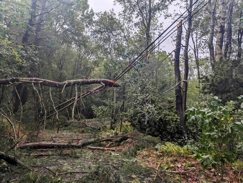
As Lee transitions from a Category 1 hurricane to a post-tropical storm, meteorologists say it will remain a threat because it will expand and maintain much of its strength across an area extending 300 kilometres from its centre.
Environment Canada has issued hurricane watches for the southwestern Nova Scotia counties of Digby, Queens, Shelburne and Yarmouth, where hurricane-strength winds could gust as high as 120 kilometres per hour on Saturday. As well, a hurricane watch is in effect for Grand Manan and the southern coast of Charlotte County in New Brunswick, where gusts across the Bay of Fundy could also reach 120 km/h.
"Those are the areas that are going to see the strongest winds," senior meteorologist Bob Robichaud told an online briefing Thursday. "There are going to be a lot of other areas in the Maritimes where it's going to be a windy day, but not experiencing damaging winds."
The strongest winds are expected to pull down trees and knock out electricity, the centre said.
Residents of Nova Scotia's Atlantic coast and those living near the Bay of Fundy in New Brunswick are also being warned that significantly higher water levels could lead to localized flooding and dangerous surf.
Along the Atlantic coast, breaking waves are expected to reach four to six metres. Rough conditions are also expected around the Bay of Fundy, the Gulf of Maine and the southwest Maritimes marine district.
The large waves and storm surge could result in coastal flooding during the high tide around noon Saturday in Shelburne County, then during the high tide late Saturday along the Nova Scotia coast from Queens County to eastern Halifax County.
Meanwhile, lineups for propane refills were a common sight across the region. Along the southern coast of New Brunswick in St. George, residents were flocking to the hardware store to pick up flashlights, batteries and candles.
Lindy Sullivan-Koteff, a manager at the Boyd Bros. Home Hardware Building Centre, said the store sold three generators on Thursday. Normally, they sell one a month.
“A lot of the customers in today have been getting stuff to prepare, to tie things down,” she said.
On Grand Manan, residents were picking up or tying down anything that could become a projectile in high winds, said Melanie Sonnenberg, general manager of the island’s harbour authority.
“Storms are not uncommon here, but a hurricane-force storm is a bit different,” she said in an interview. “So we’re turning our minds to what’s going to happen.”
Sonnenberg said the local harbour master was on the wharf to make sure boats and belongings were secured. It was a difficult task, Sonnenberg said, as the ports are full because preparations were being made for the lobster fishing season.
“I’d rather be over-prepared and underwhelmed than under-prepared and overwhelmed," she said. "That’s how everyone is approaching this.”
At the Canadian Hurricane Centre in Halifax, Robichaud said there wasn't much concern about storm surges around the Bay of Fundy because the arrival of the storm will not coincide with the highest tides of the month.
"We don't anticipate a major problem," he said. "Given the intensity of the storm and its track, it doesn't appear to be something too severe at this time."
By Thursday afternoon, the Category 1 hurricanewas west of Bermuda, churning out sustained winds at 140 kilometres per hour.
Meanwhile, tropical storm watches were issued for the western half of Nova Scotia and southern New Brunswick, including Saint John County, Fundy National Park and Moncton. These areas, which stretch as far east as Halifax, could see sustained winds of 60 km/h with gusts up to 100 km/h.
In advance of the storm, a separate weather system dumped rain over much of the region Thursday. More rain was expected Friday.
"These bands are notoriously difficult to predict, but it is important to understand there is a flooding risk with these bands well before the arrival of Lee," the hurricane centre said in a statement. "Additional rainfall from Lee itself could exacerbate the risk of flooding."
With the latest shift eastward to Lee's predicted track, meteorologists say the threat of heavier rain has shifted to western Nova Scotia, central New Brunswick and northward into Quebec's Gaspé region and the province's Lower North Shore. Rainfall totals in excess of 100 millimetres are possible in some areas, especially in areas to the left of the storm's track.
"The ground is saturated," Robichaud said. "We've had an extreme amount of rainfall over most of Nova Scotia over the course of the summer. This is certainly not going to help."
Still, he said most of central and eastern Nova Scotia will avoid the heaviest downpours.
In Prince Edward Island, which suffered extensive damage a year ago in post-tropical storm Fiona, officials stressed they were not expecting a major impact from Lee. But they encouraged residents to review emergency plans and prepare for 80 km/h winds, heavy rain and possible storm surges.
"Islanders have been strong and resilient to storms that have hit our province over the past few years," Public Safety Minister Bloyce Thompson said in a statement. "We have learned that the best defence is to properly plan for a weather event before it arrives."
This report by The Canadian Press was first published Sept. 14, 2023.
— With files from Sarah Smellie.
Michael MacDonald, The Canadian Press