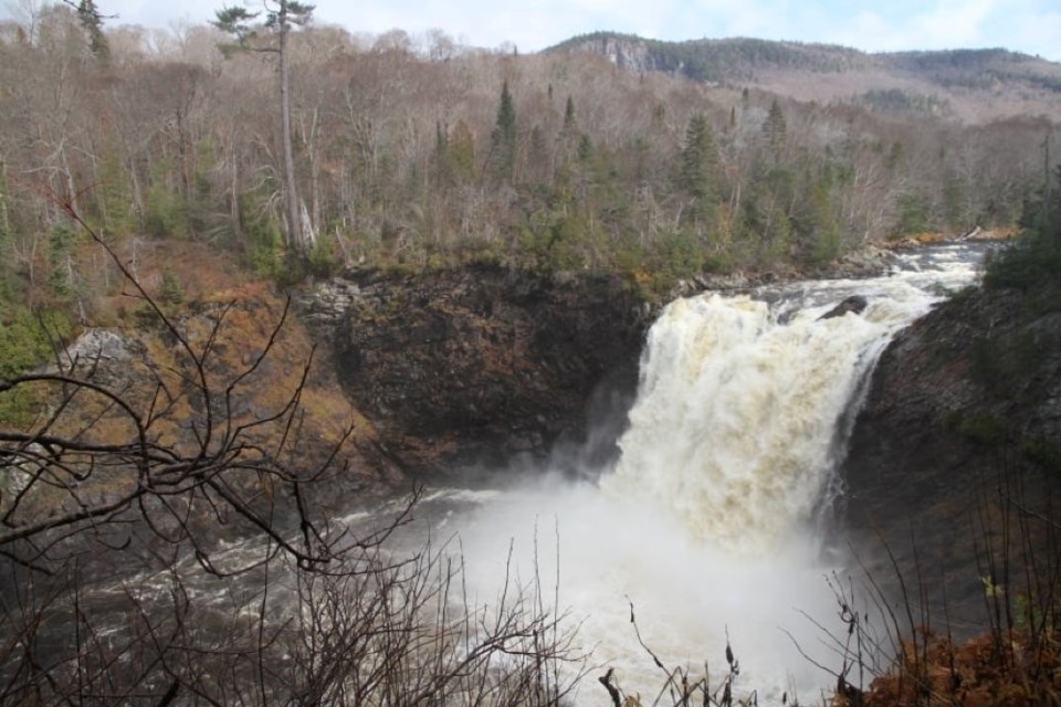
Last week’s new High Falls story got me thinking.
The summer is here and there’s been a steady amount of rain in most areas. Not much chance for wildfires in our neck of the woods, this year. Therefore, some of the waterfalls are worth the visit because of these peak deluges we are having.
As we are moving across the north there are a number of cataracts yet to visit for good reasons other than the sights and sounds of moving water – gravity is the reason.
Waterfalls of Ontario
But first the definitive source of waterfalls in Ontario.
Waterfalls of Ontario is celebrating 25 years of finding moving water. The interactive map is a “go to” detailed link to save.
Mark Harris is the originator and was featured on a recent Back Roads Podcast.
There are 40,000 Waterfalls of Ontario members on Facebook with the help of a dedicated group of volunteers. Mark has also released a coffee table book.
Nobody knows exactly how many waterfalls are found in Ontario. Harris’ book lists more than 600, but he admits that there are many more.
“Many waterfall sites also have second or third smaller falls just around the corner from the main attraction," he said. "At places like Duschesnay Falls in North Bay, or at Sand River Falls near Wawa, it seems like the falls just keep coming!
"I continue to be surprised when someone posts falls that I’ve not come across in 20 years. Even in areas that we thought were fully catalogued.
"There are now daily posts of photos, directions and questions about visiting waterfalls in Ontario. The Facebook group has
brought together a number of like-minded people of all ages and backgrounds.
“Waterfalls are the centrepieces of many hikes, whether it’s a long rugged hike through the bush or a short walk down a dead-end street in small towns and villages. They have also allowed me to explore parts of the province that I otherwise wouldn’t have visited. I love the thrill of hearing the sound of the water on the rocks, whether it’s the thunder of a large spray-filled river or the trickle of a little woodland stream."
The new High Falls (Caramat-Manitowadge) is now on the Waterfalls of Ontario website and it is on Mark’s list.
"They serve as an excellent subject for photography, especially how they change from season to season. Some people like to sit and relax next to waterfalls for hours. But I’m always too busy trying to get to the next one! I’ve identified more than 600 in Ontario to date, but there are no doubt many more hidden off the beaten trail.”
I appreciate the “…the next one!” comment.
An interactive map on the site identifies waterfalls throughout the province that you can visit, and each is rated for ease of access and interest.
This is one of my favourite submissions to Waterfalls of Ontario because of the many hundreds of cars and trucks drive by each day as they drive by this Highway 11 North bound-side rock cut phenomena, and you wonder as the water goes underneath the four lanes. I found out there was a small concrete water control structure above.
Northern Ontario
Not all waterfalls have a straight drop, that is for sure. The Google classification of waterfalls says you will find about eight types including “plunges,” “horsetails,” “fans,” “punchbowls,” “cascades,” “ribbons,” “slides” and “chutes.” Take a look at the photos and your next cascade. It is like identifying cloud types.
There is the easier Sunday drive, “let’s stop and get out of the car” occasions, the falls that are day trips and the more adventuresome from the following. Included are some reasons for their notoriety.
Let’s stop
Get ready with the map link guide to see where all of these favourite falls lie.
If you are on “the Island” seek out Bridal Veil Falls, Hwy. 540, Kagawong on Manitoulin . It is a good example of a vertical fan type of falls. People love to swim in the pool and there’s always the presence of fossils. There are French fries and ice cream across the road.
Another rest stop is Duschenay Falls at the western border of the City of North Bay and Nipissing First Nation. It has a number of plateaus and you can walk up on both sides of the falls. These trails connect to Canadore College and Nipissing University.
Near the northern limit of the City of Greater Sudbury on Hwy. 144 is Onaping Falls. It is now only rep the first was that the site sits on the lip of the Sudbury Basin, a crater formed about 1.85 billion years ago when a huge meteorite measuring 10-15 kilometres in diameter slammed into the planet, there is shatter cone evidence there. The falls were painted by the Group of Seven artists. A.Y. Jackson, his ‘Spring on the Onaping River’ in the mid-1950s.
Just west of the “Soo,” on Highway 17 is the expansive Chippewa Falls. These falls were also memorialized by the A.Y. Jackson in the painting ‘Stream Bed, Lake Superior Country.’ Also at the roadside park, there is a plaque that marks the halfway point of the Trans-Canada Highway. The plaque describes Dr. Perry E. Doolittle, who is considered the father of the Trans-Canada Highway. It is a popular rest stop.
Don’t miss this, “Hell’s Gate” at Kap-Kig-Iwan Provincial Park in Englehart on Highway 11 North of Timiskaming Shores. There is a short trail loop worthwhile for the views.
There is another hidden gem, High Falls in Timmins. Head out on the 4.2-km loop trail to see the three cascades.
Approaching Wawa is Magpie Falls (Scenic High Falls) about 2.5 km off of Hwy 17 before you get to the big goose. The famous Canadian pianist, Glenn Gould made famous these falls in a CBC documentary The Idea of North.
At Terrace Bay, there is the stunning The Aguasabon Falls & Gorge. The water tumbling over 100’ (30 m) headed to Lake Superior comes from a long way away. After the upstream view, find your way to the Terrace Bay beach and walk upstream 500 m (546 yards – remember 1760 yards in a mile) to see another lower plunge with the lake in the background.
We know about the infamous cataract of the north – Kakebeka Falls on the Kaministiquia River. The 40 m (131’) high is the second-highest waterfall in Ontario with year-round access for viewing, it has a provincial park boardwalk that wraps around the brink. Read or listen to the Indigenous legend about its story.
Twenty-five kilometres west of Ignace is Raleigh Falls. There is a series of cascades all of which are of the low plunge variety with a viewing platform for the uppermost falls.
In Kenora find Highway 671 and Jones and head ENE to Morgan Falls. It is 300m off of the paved road. It is a wide-slide type of falls 6m high.
A good reason to consider the Ontario Parks day pass like a gym membership as parks have many day-use opportunities.
Day trips
These require some effort because of access.
Tills Falls is noted as the highest fall within Lake Superior Provincial Park. If the weather is favourable you can launch a canoe/kayak (or small tin boat) and safely paddle along the coastline for 2.5 km (one way).
The Eau Claire Gorge is east of Rutherglen and west of Mattawa. It is on Hwy. 654 on the way to Kiosk, the ghost town of Algonquin Provincial Park. There are three trails and watch for the side trail to the middle of the falls, just past the viewing area at the brink, it is not marked. It is one of those falls that has four different seasonable moods. See Back Roads Bill there in the winter.
It is a little out of the way but well worth it, located 109 km north of Thessalon. If you are headed to Chapleau on Highway 129 stop at the multiple cataracts at Aubrey Falls Provincial Park.
Near Dorion/Red Rock is a vertical fan falls – Wolf Falls. It is the type of drop that you can walk in behind the fan and a wonderful swim. The trail down has a short drop with a rope; an easy adventure. It is a picnic spot for sure.
East of Nipigon just off of Highway 11, ready accessible is Mazukama Falls, another hidden cataract. It is 25 m in height and tumbles straight down off of the Nipigon area palisades.
More adventuresome
These trips deserve some planning and Waterfalls of Ontario waterfall watcher/member Brian Emblin from Timmins was asked about the following. He has been to these falls from Back Roads Bill references.
Brian has been to New Post Falls many times his reflections are detailed.
“New Post Falls is a pretty large vertical drop from New Post Creek to the Abitibi River. The drop itself is into a narrow slot-like canyon. I’ve been to the falls in winter and in summer, low flow and high flow, by boat and by car. It’s always a treat because the flow can vary quite a bit. There are benefits of going with high flow, the powerful rumble of the water dropping into the canyon giving it its nickname “the beast of the northeast”. However low flow you can walk up to the lip of the canyon and look into the abyss but as well at low flow you can get to the bottom of the canyon and have a nice view of the falls from below.
“I find this fall provides the best shock and awe when you make it to the end of the trail from the parking lot and you first glimpse the canyon and falls.
“The level of effort to see the falls is fairly low if you go by vehicle, a drive and a short walk. But it’s fairly remote, well beyond cell range which some people are not comfortable with. The road in is sometimes questionable with washouts and fallen trees.”
Thunderhouse Falls on the Missinaibi River can be accessed in the winter and summer (canoe trip). An outfitter, Follow Her North will get you there winter or summer.
Brian says, “Less of a huge vertical drop more of a stretched-out drop. The signature feature is the obelisk rock slightly downstream called Conguring Rock. I’ve been in winter by snowmobile and snowshoes. and in summer by freighter house canoe.
“The best time to see the water running is spring but there is a certain “badge of honour” knowing that you snowshoed in the 10 km to see the spot in the winter. Europeans arrived. There is a beautiful lookout/campsite halfway along the portage that has
been told to me was ranked one of the most beautiful campsites in Ontario. The level of difficulty getting there adds to the mystique of the place. These falls are on the north side of the height of land surrounding James Bay
He says, “It’s interesting that New Post and Thunderhouse are nearly at the same north latitude, almost as if the ground took a giant drop at that line.”
Agawa Falls are not seen from the fall colours excursion train. They can be hiked to in a couple of ways.
The Lake Superior Provincial Park-Towab Trail is classified as “Very Demanding; 24 km (15 mi) return, linear; 8 - 14 hours and the trailhead is located 3.5 km (2 mi) along the Frater Road.”
Brian describes: “Agawa Falls is your traditional broad-faced vertical drop. It’s very picturesque. The falls are nice but I think New Post provides more of an instant awe when you see it, maybe due to the canyon. Agawa Falls is on the southern side of the height of land surrounding James Bay. There seem to be many more falls on the south side. I’ve only been once and the flow was great. I went by foot, not on the designated hiking trail but a shortcut “bush whacked” from an old logging road past the Frater station.”
In some senses, a waterfall or set of rapids is nature at its most rudimentary, a simple case of physics. It is the emotional part of a science application. We wonder about and wander towards falling water on the back roads. See how many you can check off the list.


