Last week, in part one of three stories, it was Sunday drives, easy enough to do with your vehicle and learn from the destination.
It is day trips this time meaning moving to a destination and then maybe walking or hiking, canoeing or kayaking, mountain biking or using your ATV/power boat. There is some planning and a timeline within your daylight preparation.
Swimming Hole
If you want to cool off and are looking for a good ‘ole swimming hole the Blue Lagoon is an interesting day trip follow the directions closely.
“Most canoeists who pass along the river don’t even know it exists as it lies off the portage and across from the main course of the Chiniguchi River and associated waterfall. Most people see the falls but portage right past the lagoon. The water of this
circular, seemingly bottomless lagoon is often described for its “Windex” like colour and is surrounded by steep rock walls of granite and quartz. Its colour scheme is a hangover from the past acidification of area lakes by the original smelters in nearby Coniston and Copper Cliff. Access is by water or a secret back roads access by car. It could be a scene from the movie of the same name or somewhere in the Caribbean. It might be a “sit,” “magic,” or “me” spot. One of those places for solace, inspiration and rejuvenation or, just a great swimming hole on a hot summer’s day.
As a bonus, on the same back road, move north a bit and see some of the largest red pine stands in the world on Wolf Lake. If you have an ATV or a mountain bike you can access Wolf Mountain for an expansive vista.
You can also day trip canoe from the Matagamasi MNR Boat Launch or take your ATV or mountain bike.
Look way up!
We have big trees and old ones too in Northern Ontario.
Wherever you are in Northern Ontario the majestic white pine will speak to you. Where is the largest white pine anyway? You can now go on a treasure hunt to find the tallest or widest.
Trees are our largest plants and it is not hard to identify the white pine from near or afar. We learn to differentiate the white pine from its close cousins by its characteristic bundle of five long needles corresponding with the five-letter word, 'w-h-i-t-e.' In the upper part of the tree, the branches ascend, giving a broadly oval flat-topped outline which often becomes irregular, or asymmetrical, attributed to the effect of the prevailing northwest winds.
You can hike from the trailhead at the Temagami Fire Tower within the town. There are a number of trails within the Caribou Mountain/White Bear Forest network and the largest red and white pine are 500 m SW of A4. A wonderful hike and canoe option exists by putting your canoe in at A7, accessed from the town on Fox Run Rd.; it is about a 37-minute paddle to the trailhead in the little bay (A4).
On another day you can drive and hike to Marten River Provincial Park where there are also some giants to look way up on the Old Growth Trail.
Pictographs
There are two-day trips to choose from here, both are wonderful opportunities to learn about Indigenous history-cultural practices.
“The art of pictograph painting is thought to date back more than one thousand years in Ontario.
"Not until the late Selwyn Dewdney embarked on a lifetime study of rock art did we realize the importance extent and meaning of these drawings. Dewdney recorded close to 300 pictograph sites from Saskatchewan to Quebec and the northern states bordering Canada.
"It became a passion for the artist/teacher and it brought him to sketch and record the sites in the late 1950s and ’60s.
"Find his book, with Kenneth Kidd, 'Indian Rock Paintings of the Great Lakes.”
These could have overnight options – water-based, so canoes or power boats. One is Fairy Point on Missinaibi Lake – Missinaibi Provincial Park and Kennedy Island, Upper French River – Lake Nipissing with access from Dokis First Nation.
One more, if you are travelling Highway 17 stop at the Agawa Rock pictograph site within Lake Superior Provincial Park between Sault Ste. Marie and Wawa. Check out the map here.
Remembering
He was a trailblazer before there was Truth and Reconciliation.
To blaze a trail is to lead the way, to be a pioneer in a field or to clear the road for others to follow in your footsteps.
John Sanders was the first, Indigenous Anglican minister in northern Ontario and one of the first in Canada. Sanders contributed greatly to mission work with his translations into Ojibwa. It was also the time of the advent of residential schools.
He is buried in an overgrown cemetery close to the CPR tracks near Missanabie, in the middle peninsula of the elongated Dog Lake. Where’s that and who was he? This cultural story is about putting together a lifetime of puzzle pieces within two nations.
Here is how to get there.
Since you are near Chapleau, visit the commemorative monument related to one residential school.
If you want to visit Romeo and know about lifeline and important “resolve” this story is along Hwy 651, on the way to visit John Sanders, and it is one of those abandoned cemeteries that dot the rural landscape. The map has more than 31,000 views. Take a small rock and leave it near the headstone.
Mystery Spa
This day trip is suitable for ATV enthusiasts or it will be a longer hike to one of the back road's unsolved mysteries.
You could help solve a million-dollar mystery, one that's not your ordinary old logging camp or mining adit.
It is one of those bush puzzles that, when you stumble upon it, you ask “What was going on here?” You could not drive there then or now, the questions have some answers.
The crumbling, concrete, rectangular-shaped cistern is covered in lichens and mosses. An old pipe sticks out at one end, severed but headed about 200 m in a linear direction, down a slope to where there was a health spa, cabins and a health clinic.
The water is clear and almost still but the Artesian well continues to emanate from fissures deep in the earth’s crust, creating a subtle wave of movement on the surface. The aging cistern protects supposedly magical waters and an interesting timeline.
Bethnal Springs is a multi-element mineral spring that has been flowing consistently from recorded discovery in 1910.
Here is the access. This map has more than 52,000 views and, through Sudbury.com, it has been shared more than 500 times.
Vista
The walk to the vista is 20 minutes one way, sneakers are fine, and it is the best vista in Northeastern Ontario.
It may not be akin to Prudential Insurance’s long-standing Rock of Gibraltar logo but it seems to be headed that way. Community businesses are dispelling the notion that one of northern Ontario’s best and most accessible vistas is seldom seen, the dramatic drop is becoming iconic.
Devil’s Rock on the west side of Lake Temiskaming near North Cobalt rivals the Barron Canyon in Algonquin Park and the Ouimet Canyon east of Thunder Bay. It is not just the sheer height of the cliffs that take your breath on the way. The 180°- plus panoramic view has an uninterrupted sightline in three directions.
You won’t see a sign on Highway 11 North urging you to “exit here” to Devil’s Rock. On the standard 1:50 000 topographic map, it is called Devil Rock. Three very different businesses have branded some of their offerings utilizing the iconic vista.
You may have a copy of the Hardy Boys book.
Here is the full story from Oct. 28, 2020.
and another story that looks at how local businesses have capitalized on the Devil’s Rock destination. A tip: to see the rock face walk as far as you can to the north or left, people often miss this view.
And you are in Cobalt mining history territory so might as well take in the Heritage Silver Trail.
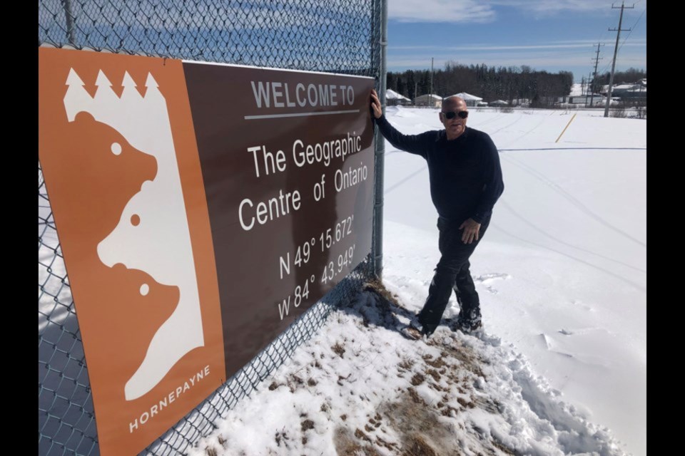
Center of Ontario
It may be the most difficult of day trips because there is a little bushwhacking to do.
“The first trek to the centre was in 2018, there was a second visit and then the concept of notoriety was presented to the Mayor and Council of Hornpayne early in 2020.
I wore and presented a T-shirt to the Mayor. Then the pandemic engulfed us. On April 10 the third trip to the destination ensued, just a few kilometres off of a logging road to the NNE of town.
"Hornepayne, the Geographic Centre of Ontario, is looking forward to the fruition of a walking/hiking trail into this valuable location within our province and country. The Township has established an Ad Hoc Committee that is eager to get this project going and has some productive ideas," said Mayor Cheryl Fort. "Although the pandemic has hindered the development over the past two years, excitement for the project has not wavered. The Committee, Council and our entire community are committed to seeing the Geographic Centre of Ontario develop into an ecotourism site for generations to come and explore. We are excited to resume working on this exciting project for our community!”
Hornepayne is between White River on Highway 17 and Hearst on Highway 11. If you don’t want to undertake the hike there is a selfie sign at the ball field in town denoting the geographic significance. But the braggin’ rights are worth it.
After the center, Back Roads Bill went to the four corners of the province including the challenge of the north.
Next week, story three will be about overnight treks. Start getting organized for the back roads.


