A committee looking to improve the city’s street and trail network over the next 10 years has completed its second of three broad public consultation meetings to develop a master plan
For the past month Active Transportation North Bay has met with schools, interest groups and anyone else who makes use of the trail system or who wants to use the trails.
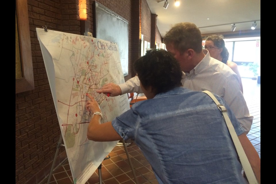
“We had a previous session where we looked at the trail and street networks that we want to connect, to make an active transportation network for the whole city,” said Jim Scott Landscape architect and planner with Trace Planning and Design.
‘So what are the routes we want to make more friendly for bikes, for inline skaters, for walkers? We have to decide if a network makes sense, and how we should treat some of these network pieces. So what should we do to streets to make them work better, and what kind of stuff should we do to trails?”
Paula McCloskey, Senior Manager of Parks, Recreation and Leisure Services for North Bay, said the committee has taken all the input from the past month and put together a preliminary draft for the public to review, and provide comments about what they like or don’t like.
“The whole driving force behind this Active Transportation Plan is the ability for people to walk out their front door and have choices. And those choices aren’t always to pop in their car and go about their business,´ said McCloskey
“It’s all about connecting people from the end of their driveway, through their neighbourhood, to citywide systems that take them not only for recreation and tourism interests but for commuter purposes as well. So if they want to go to the bank, or they need to go to work, we have a system in place that encourages people to be active, limits motorized transportation, takes advantage of our existing transit system and basically is friendlier to our environment and healthier to our bodies.”
Scott said 80 per cent of everyone who provided input at the second session, want to see something happening along Trout Lake Road.
“And the trail systems on either side of that to make it better for people who live in that entire area of the city to get downtown. That was a big one, and we talked a fair bit about the Kate Pace Way. There’s sections they would like to see maybe move away from the street where it’s presently on a street, and then a lot of discussions focused on some of the intersections. Can we make them safer, tie them in with the transit system?”
A mock-up based on suggestions from the last session gave a clearer idea of what people wanted.
“We can do things with streets, we can do things like shared corridors, really just marking the street and signing them. We can do things like bike lanes if we have the space, but in most cases, we don’t have the space. We can look at long-term plans that see us building multi-use trails like the Kate Pace Way or the Kinsmen Trail that is built along the sides of these streets in the future and have them work together with the transit system. So we’re testing those ideas.”
Bill Ferguson is an avid trail user, having biked over 800 kilometers this year already. He would like to see better maintenance of existing trails.
“I think the trails that we have right now are a good start. My concern is that there’s not sufficient maintenance. There are holes and issues on the current Kate Pace Way down at the portion towards Callander. They have been there going on two years now, and they make the trail less than ideal for people on road bikes,” said Ferguson.
“I certainly would like to see expansion. I’d like a dedicated trail, but there has to be a commitment to maintenance. And the south part of the trail between Decaire and Cranberry Marsh Road, there have to be some cutbacks so that the roots are not lifting the asphalt and that’s what’s happening right now down there. So I think it should come out to more of trail standard and you don’t have that issue. But certainly it’s nice to have it and I enjoy using it.”
Gordan Rennie hopes the study isn’t just a document that ends up on a shelf.
“I don’t think we really need to build a lot more trails, I think we just need to put some money into maintaining existing roads. One idea I have is when you go up past the college, and you keep going, if there would be a way to tie in the end of Larocque Road over to Barnet Road that comes out to Highway 11, and then down Marsh Drive to Four Mile Lake Road, you’d really get a nice long route for cyclists to get in past the airport and with minimum cost to the city,” said Rennie.
“So I think when they’re looking at the study as a taxpayer and a cyclist, I think there’s a lot of easy solutions to make a more robust system in North Bay without really investing a lot more dollars, but it’s going to take focus.”
As a cyclist Jim Sinclair wants the final design to include ways for everyone to safely share the space.
“One of the things I think has to go along with a design is how to get the best behaviour out of everybody using the trails? I would like to see that the planners take into account the potential of either using or developing shade as part of the design. I know it can be done because I’ve been in more than one city where it has been a factor, and people are doing it. And I think the health unit could be a welcome and active partner in the planning.”
“We’ve reached out in as many ways as we possibly know and we’re going to continue to refine the product and hopefully, in the end, come up with a system that benefits the city of North Bay,” said the senior manager for Parks, Recreation and Leisure Services.
“We’re aiming for September to do a presentation to council as a result of the community input into this plan.”


