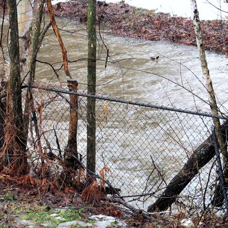
Current water level on Chippewa Creek between Chippewa and Aubrey Streets. NBMCA has issued a Flood Warning for the Creek.
North Bay Mattawa Conservation Authority
News Release
*****
The Flood Warning for the Chippewa Creek subwatershed has been lifted by the North Bay-Mattawa Conservation Authority as the receding water levels are now below top of bank.
A Flood Watch is still in effect for all other major watercourses including the La Vase River, Parks Creek, Duchesnay Creek, Wasi River and watercourses flowing into the Mattawa River system.
“Localized areas are still experiencing minor flooding and some larger watercourses such as the La Vase River are continuing to rise as they receive runoff from yesterday’s rain and warm temperatures. They’ll slowly recede in the next 24 hours since the temperatures have dropped below zero, but there remains the added risk of ice jamming in streams where ice is still present,” said Susan Brownlee, NBMCA Regulations Officer.
Municipalities, emergency services and individual landowners in flood-prone areas should continue to monitor conditions and be prepared.
“We’re not anticipating any rain to fall in the next two days, however the melting of the snow pack continues and precipitation is expected towards the end of the week,” she added.
Today’s measurements of the snowpack showed a 25-35 cm drop in the snow pack over the past week with snow water equivalents dropping in the Wasi River subwatershed from 40mm to 5mm, in the LaVase River subwatershed from 80mm to 5mm and in the Chippewa Creek subwatershed from 95 mm 6.6 mm.
All residents, especially those in low lying areas, are encouraged to monitor the conditions that are developing.
Banks adjacent to rivers and creeks are very slippery at this time and when combined with cold open water, pose a serious hazard.
Parents are encouraged to keep their children and pets away from watercourses and off water bodies that have unstable ice conditions.
Municipalities are encouraged to monitor water crossings to ensure the continual movement of water through culverts and bridges.
A close watch on local conditions and updated forecasts and warnings from Environment Canada is also recommended.
Monitoring weather and flood conditions is a shared responsibility of NBMCA, Ministry of Natural Resources (MNR), and Environment Canada.
When flooding is possible or about to occur, NBMCA issues flood messages to municipal emergency management officials and the media. The municipal officials then take action to warn local residents.
Flood forecast messages enable the municipalities to prepare for, track and manage local flooding.
Advance warning by NBMCA provides municipalities with the opportunity to put emergency plans into operation, evacuate communities if necessary, and secure property in areas that are more likely to flood.
NBMCA advises the general public through the www.nbmca.on.ca website with the flood status icon and a link to information about current conditions. NBMCA also issues these messages to the public through local media, twitter @the NBMCA and on facebook.com/NBMCA.
The public is invited to submit photos of any watershed conditions to twitter @theNBMCA or email [email protected] .
A close watch on local conditions and weather forecasts from Environment Canada is also recommended. Environment Canada bulletins can be found at http://weather.gc.ca/
Other information is available on the Surface Water Monitoring Centre public webpage: www.ontario.ca/flooding.
*****
Rain and snow melt over the past 24 hours, and additional rainfall of 20-40mm expected throughout the day have raised Chippewa Creek’s flow and levels in the City of North Bay resulting in a Flood Warning being issued for the Creek.
A Flood Watch is also issued for the La Vase River, Parks Creek, Duchesnay Creek, Wasi River and Mattawa River system watersheds.
“Municipalities, emergency services and individual landowners in flood-prone areas should prepare. Stream flows in the area are continuing to increase due to the recent mild temperatures and rainfall. Minor flooding is taking place in low-lying areas. Chippewa Creek has reached its 1:5 year level,” said Susan Brownlee, NBMCA Regulations Officer.
The widespread rain that fell overnight and above-zero temperatures experienced over the past few days continue to affect local watercourses.
Rainfall is expected to occur throughout the day today, falling heavy at times before turning into snow later this afternoon or this evening.
Total rainfall amounts of 20-40mm are possible by this evening.
“The fact that the ground remains frozen and/or saturated will aggravate the situation in problem areas as the ground will be unable to absorb the excess water. Additionally, there is an added risk of ice jamming in streams where ice is still present,” she added.
All residents, especially those in low lying areas, are encouraged to monitor the conditions that are developing.
Banks adjacent to rivers and creeks are very slippery at this time and when combined with cold open water, pose a serious hazard.
Parents are encouraged to keep their children and pets away from watercourses and off water bodies that have unstable ice conditions.
Municipalities are encouraged to monitor water crossings to ensure the continual movement of water through culverts and bridges.
A close watch on local conditions and updated forecasts and warnings from Environment Canada is also recommended.
This message will be in effect until Tuesday, April 15, 2014.
Monitoring weather and flood conditions is a shared responsibility of Conservation Authorities, Ministry of Natural Resources (MNR), and Environment Canada.
When flooding is possible or about to occur, NBMCA issues flood messages to municipal emergency management officials and the media. The municipal officials then take action to warn local residents.
Flood forecast messages enable the municipalities to prepare for, track and manage local flooding.
Advance warning by NBMCA provides municipalities with the opportunity to put emergency plans into operation, evacuate communities if necessary, and secure property in areas that are more likely to flood.
NBMCA advises the general public through the www.nbmca.on.ca website with the flood status icon and a link to information about current conditions.
NBMCA also issues these messages to the public through local media, twitter @the NBMCA and on facebook.com/NBMCA. The public is invited to submit photos of any watershed conditions to twitter @theNBMCA or email [email protected].
A close watch on local conditions and weather forecasts from Environment Canada is also recommended. Environment Canada bulletins can be found at http://weather.gc.ca/
Other information is available on the Surface Water Monitoring Centre public webpage: www.ontario.ca/flooding
*****


