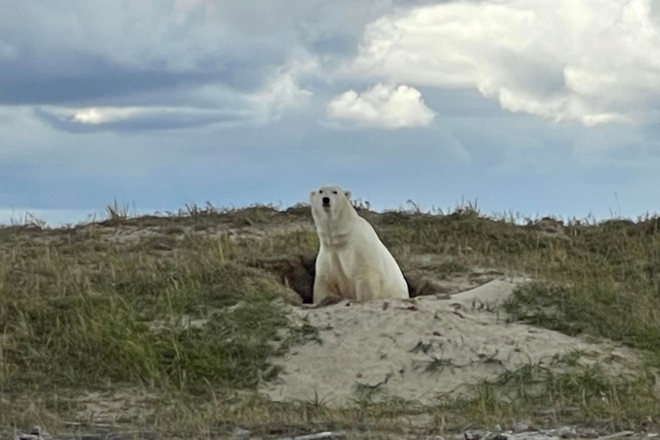
The geographic centre of Ontario and the three boundaries/corners have been visited; the north beckons and it’s in polar bear country where there are no back roads.
It is time to fly from Sioux Lookout (Oct. 2) on Wasaya Airway Flight #WP749 to Washaho Cree Nation (Fort Severn) the province’s most northern settlement. We then make our way Northwest along the Hudson Bay coast to the most northern point in Ontario that borders Manitoba and Nunavit. It is a test.
This story started three years back when the centre of Ontario became the first challenge, who knew then where the centre was?
Centre
Getting to the centre of Ontario started before COVID and we have been there three times on snowshoes. The very middle of the province is located in a mature forest of black spruce, very tranquil and now a community is putting forth an effort to make it a tourism icon.
East and South
Believe it or not, we journeyed to the most eastern and southern points in Ontario within a 24-hour time span. The east was at the end of someone’s driveway bordering two provinces. The Ontario side of the driveway is County Rd. #2 and then it immediately changes to Ch. Frontiere (Chemin) on the PQ side.
The most southern point in the province, where there are vineyards. There is so much biodiversity and so many birds, especially in the spring. It required a ferry ride and some water wading.
West
Each point of the province has provided new challenges the most western meant we had to leave Ontario, enter another province and into the USA! It was instantly American dollars, miles, Fahrenheit, MPH and flags everywhere. Entering our neighbour to the south, where there is no manned border was interesting and when we got to Angle Inlet there was flooding to contend with.
North
So now it is tundra and tides we’re on part of an ocean.
The Hudson Bay Lowlands, a wetland area of Canada covers about 320,000 square km (123,553 square miles) on the southern shores of Hudson Bay and James Bay, surrounded by the Canadian Shield. It is the largest area of wetlands in the world. It falls largely in Ontario and Manitoba and Fort Severn is located almost near its centre. What we will find is level plains of tundra and bog-like muskeg and peat, dotted with shallow ponds.
The most northern boundary is now the most challenging. Teaching outdoor education and survival skills says the priorities will be to keep dry and warm and retain that positive attitude when you are in remote situations. For this trip it will be to keep warm and dry and maintain a positive attitude.
Having hiked in Iceland and Greenland the terrain will be similar and different. Instead of crossing terrain we are making our way along the mud, tidal flats and fording more than twelve estuaries with ATV’s. Most are small but there are a couple of very wide river mouths. Salt water is hard on the machines.
Fort Severn (Washaho) is a Western Swampy Cree First Nation (FN), the population in 2016 was 361. Previously, the “official” reserve was located more than 150 kilometres to the south, at the junction of the Severn and Sachigo rivers, known as Rocksands. On the Washaho FN website there is some foreshadowing of what is to come. “Traditional knowledge… means that you know almost every lake and river on the land….But if you know the lands, you grow up on the land the difference is that you are a survivor on the land. With the new technology like GPS, it can take you where you want to go. But one thing that doesn't tell you is the condition of the terrain. Like if you were to cross a creek like that during the night…and this little creek happens to be only about this thickness of ice — it's not frozen, eh — you'll be heading straight into the water. Even though that GPS tells you where your camp is, it doesn't tell you that ... That's the problem with the new technology.” Here is a short Washaho YouTube video.
We will be with our guide George Kakekaspan (Kah-kee-kas-span) he has the “traditional knowledge.” He was born in Sioux Lookout and raised in Rocksand, Winisk and Fort Severn. He is Canadian Armed Forces, reservist, a Canadian Ranger for more than twenty years; he has been guiding since the age of eighteen. He also runs, “a store and gas business out of my home.” He says, “The water levels in the rivers are low;” that’s in our favour.
Brian Emblin from Timmins has been a co-pilot all the way along with these destination adventures.
“I've been looking forward to this for some time. The other three extreme points and centre point pale in comparison to this one for its effort and planning. Really luck my pal Bruce hooked us up with our guide George. I've never been that far north before I'm sure it will be an education and I look forward to seeing the scenery, meeting the people and getting a peek into how people live there.”
We are utilizing community members’ hunt and fish camps along way; shelters made of frames, wooden poles and canvas; they’re called Black Current, Niskibi cabin and Mintiagon cabins. We have to cross more than 12 small tidal estuaries, most are small but there at three larger ones with alluvial fans and there are the tides to consider. The saltwater is hard on the ATVs. The distance is approximately 140 km.
I am nervous but prepared; I am not 23 anymore but maybe wisdom and experience of years gone by will help. At the time of submitting this story the weather looks favourable with daytime highs of 9 degrees C and lows of 5 degrees C at night, with no precipitation (that white word) in sight.
Map
The map will help with orienting the extreme boundaries of the province and the journey that awaits. As it should be the distance between the N-S and W-E extremes is approximately 1,600 km (995 miles) based on the lines of longitude and latitude and the curvature of the Earth.
Right now as you read this we should be approaching the “summit” and will report back to you about polar bears and a place worth waiting for, beyond the back roads.


