 North Bay Mattawa Conservation Authority
News Release
*****
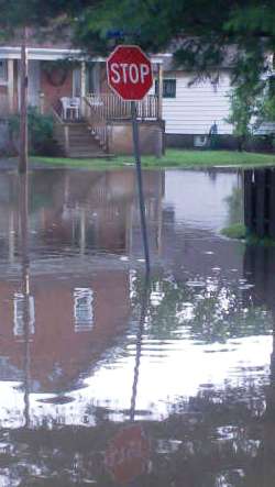
Four days of rain is expected beginning Tuesday, with approximately 25 mm forecast for the next 48 hours; and a total accumulation of around 50mm possible by Friday prompting the North Bay-Mattawa Conservation Authority to continue its Flood Watch for the area.
An update will be provided Thursday May 1st.
The Flood Watch remains in place for major watercourses, including the La Vase River, Duchesnay Creek, Wasi River and waterways in the Mattawa River System.
Municipalities, emergency services and individual landowners in low lying or flood-prone areas should continue to monitor conditions and be prepared.
The NBMCA continues to advise that area watercourses are cold and fast flowing.
Any creeks or lakes that may still have ice cover are considered unstable.
These areas should be avoided.
Parents are encouraged to keep their children and pets away from watercourses and off water bodies that have unstable ice conditions.
Municipalities are encouraged to monitor water crossings to ensure the continual movement of water through culverts and bridges.
A close watch on local conditions and updated forecasts and warnings from Environment Canada is also recommended.
Monitoring weather and flood conditions is a shared responsibility of NBMCA, Ministry of Natural Resources (MNR), and Environment Canada.
When flooding is possible or about to occur, NBMCA issues flood messages to municipal emergency management officials and the media.
The municipal officials then take action to warn local residents.
Flood forecast messages enable the municipalities to prepare for, track and manage local flooding. Advance warning by NBMCA provides municipalities with the opportunity to put emergency plans into operation, evacuate communities if necessary, and secure property in areas that are more likely to flood.
NBMCA advises the general public through the www.nbmca.on.ca website with the flood status icon and a link to information about current conditions. NBMCA also issues these messages to the public through local media, twitter @the NBMCA and on facebook.com/NBMCA.
The public is invited to submit photos of any watershed conditions to twitter @theNBMCA or email [email protected] .
A close watch on local conditions and weather forecasts from Environment Canada is also recommended. Environment Canada bulletins can be found at http://weather.gc.ca/ Other information is available on the Surface Water Monitoring Centre public webpage: www.ontario.ca/flooding.
*****


